|
0 members (),
54
guests, and
26
robots. |
|
Key:
Admin,
Global Mod,
Mod
|
|
 A John Muir Route, Part 1
|
Joined: Feb 2011
Posts: 1,572
|
OP

Joined: Feb 2011
Posts: 1,572 |
Well, I am about as decompressed from my John Muir Route as I think I can get. Spoiler alert, I covered about half the mileage that I had identified as a potential itinerary, about 142 out of a possible 275, a total of 2 on the JMT, in the time I had allotted (3 weeks) but I would call it spectacularly successful as to this Part 1 of my Route. I have an early season snowstorm of new ideas in my head, and am more convinced than ever of the of the rich rewards waiting those who make the effort to plan and follow a John Muir Route. I learned a lot about the value of detachment from the metrics of any hike - mileage, elevation gain and losses, time, weight, calories, all of that - and immersion in the experience of the thing, what Thoreau called "the essential facts of life". I had - and spent - a lot of time debating with myself and my imagined companions - including some of you reading this - the various merits of the state of some of the side trails I took (fair to non-existent) distributing visits all around the wilderness vs, concentrating them all on a few main trails, "extraordinary opportunity for solitude" (5-6 days at a stretch), instantaneous satellite communications and much more. I'll be writing more about each of these over the next week or two.
Route was Glacier/Illilouette to Ottoway Lakes, Red Peak Pass to upper Merced drainages (3), Isberg Pass to Isberg Lakes and Granite Creek, Hemlock Crossing, Corral Meadow, Mammoth Trail to Grantie Stairway and DPP, back trails to Red's. Rainbow Falls/Middle San J to Fish Creek/Iva Bell, Minnow Creek to Lone INdian and Papoose, Goodale Pass to VVR, Bear Creek CUtoff to Bear Creek to JMT to Hilgard Branch, Lake Italy, Italy Pass and Pine Creek TH. 142 miles, 2 miles on the JMT. Part 2 Picks up at Pine Creek, PC Pass, French Canyon to Piute, Goddard Canyon and points south, to somehwere around Whitney.
Film at JMT FB page.
Last edited by saltydog; 08/25/17 08:19 PM.
Wherever you go, there you are. SPOTMe!
|
|
|
Re: A John Muir Route, part !
|
Joined: Apr 2012
Posts: 579 Likes: 3
|
|
Joined: Apr 2012
Posts: 579 Likes: 3 |
Salty,
Sound like a lot of material to contemplate.
For me, I hope you will supply a map with all of these places noted. I think I recognized a total of 6 of the mentioned destinations:-)
I also did re-activate my FB account, just to see your video, but alas, I did not see it on the JMT FB site, or on your FB site (I did enjoy your Texas joke). How did I miss it?
Sounds like a magnificent adventure. Looking forward to hearing more of the details.
John
Last edited by John Sims; 08/24/17 03:37 PM.
|
|
|
Re: A John Muir Route, part !
|
Joined: Feb 2011
Posts: 1,572
|
|
OP
Joined: Feb 2011
Posts: 1,572 |
John: Its beyond my computer skills to transfer a map here, if you want to go to say CalTopo or GMap 4, start at Glacier Point, south on the Panorama Trail until it turns east toward Illilouette Falls, there continue south to Buena Vista trail across Ilillouette Creek, continue south to Merced Pass Lakes, bang a left to Ottoway Lakes and continue to Red Peak Pass. From there Continue east above red Devil Lake, drop down into Merced Paek Fork of the Merced and triple Peak Fork of the Merced, bang a right up and over Isberg Pass, leaving the Park. Drop down to Isberg Lakes, then continue south southeast to the wilderness boundary near Cora Creek, make a hairpin left back north northeast to Hemlock Crossing on the North San J, hook another hairpin right go SSE again to Corral Meadow, left on the Mammoth Trail to Granite Stairway and drop into devils Post Pile, back trails to red's Meadow, being careful to step across, not on the JMT. Heading South from Red's past the corral, step across the JMT again and take the Rainbow Falls trail all the way down to Fish Creek and Island Cossing, sharp left up Fish Creek to Iva Bell, bear right on Minnow Creek trail to Lake of the Lone Indian and Papoose Lake, then climb S to Goodale Pass to VVR. From VVR, take the Bear Creek Cutoff at the S end of the VV Dam to Bear Creek, go east up the Creek to the JMT junction. Reluctantly step on the JMT, finally and follow it South for two miles to Hilgard Branch/Lake Italy turnoff. From there follow the magical disappearing/reappearing "trail" east to Lake Italy, Jumble Lake and Italy Pass, then drop down to Pine Creek Trail, turn north and pound down to Pine Creek trailhead. I posted aout 30 shots at the FB page "John Muir Trail", and will add some video in the next day or two. https://www.facebook.com/photo.php?fbid=...e=3&theater Yep a lot of material. a book, I hope thanks for your interest
Last edited by saltydog; 08/25/17 05:29 PM.
Wherever you go, there you are. SPOTMe!
|
|
|
Re: A John Muir Route, part !
|
Joined: Apr 2012
Posts: 579 Likes: 3
|
|
Joined: Apr 2012
Posts: 579 Likes: 3 |
Well, this is my best guess as to your route. I at least came near to many of the places you mentioned  The good news is that the image is too small to take issue with, but i hope it captures the spirit of your adventure. 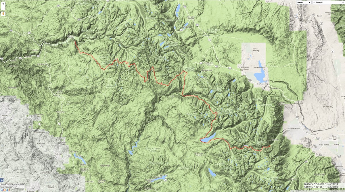
|
|
|
Re: A John Muir Route, part !
|
Joined: Sep 2009
Posts: 8,533 Likes: 107
|
|
Joined: Sep 2009
Posts: 8,533 Likes: 107 |
Actually, John, you nailed it quite well. Here's the link to Salty's InReach map. Set the filter (upper left) to Jul 19, 2017 through Aug 10, 2017 5:40 PM, and you can see all of his tracking points.
|
|
|
Re: A John Muir Route, part !
|
Joined: Apr 2012
Posts: 579 Likes: 3
|
|
Joined: Apr 2012
Posts: 579 Likes: 3 |
Actually, it was a fun exercise. As I mentioned most of Salty's way points were unknown to me, so a challenge to find them, and then to connect the dots. Thankfully gmap was there  Salty, was there any section that you particularly liked, and why? I will be up at Mammoth in Sept., and you may have inspired me to check out Lake Anona. I am guessing a 5 mile hike (one way). Any comments on the scenery from Devil's postpile to the turn off? From your InReach track it seems you may have considered this as a side trip.
Last edited by John Sims; 08/26/17 10:43 AM.
|
|
|
Re: A John Muir Route, part !
|
Joined: Feb 2011
Posts: 1,572
|
|
OP
Joined: Feb 2011
Posts: 1,572 |
Actually, it was a fun exercise. As I mentioned most of Salty's way points were unknown to me, so a challenge to find them, and then to connect the dots. Thankfully gmap was there Salty, was there any section that you particularly liked, and why? I will be up at Mammoth in Sept., and you may have inspired me to check out Lake Anona. I am guessing a 5 mile hike (one way). Any comments on the scenery from Devil's postpile to the turn off? From your InReach track it seems you may have considered this as a side trip. Dam! I was hoping no one would catch the Lake Anona Anomaly: brief foray up the wrong trail at an unmarked junction. You can benefit from that, however, by making note that the turnoff is unsigned: Mammoth trail continues left and south up a ravine, as I recall, and trail to Anona cuts along a contour into some wooded bogginess. Wrong turn here will put you on the Mammoth Trail up to the inexplicably named Granite Stairway. Some good open views with line of sight to Mammoth Mt and down into San J. Outstanding section of the hike was the upper Merced drainage (s) from Ottoway Lakes to Isberg. 2 days of a 5 day stretch in which I saw no one except a couple I had met picking up my permit, and they were only there because I had suggested a route to them that crossed mine. Very interesting crossings of Red Peak and Isberg passes, including ice ax ascents and glissade, incredible garden like scenes especially at Ottoway and Merced crossings, spectacular vistas from above Red Devil Fork of the Clark and Ritter ranges, Triple Divide and all the way to Cathedral and Dana that far surpass anything the Yosemite stretch of the JMT has to offer. Last tourists I saw were less than a mile from the Panorama trailhead at Glacier Point, and even then not many: so different from starting in the madness of the Valley. BTW, your track from my descrition was pretty good, except that you have me n Bear Ridge instead of the Bear Creek Cutoff. Bear Creek is not to be missed, especially this year with spectacular cascades, whirlpool and general spectacular water effects. I spent 2 days doing this, too. Least favorite, By the way, was south from Hemlock Crossing, and the Magical Disappearing Reappearing Trail. Sierra NF needs some serious support for their trail maintenance. it was heartbreaking to see the condition of the trails in this otherwise truly beautiful part of the Ansel Adams Wilderness.
Wherever you go, there you are. SPOTMe!
|
|
|
Re: A John Muir Route, part !
|
Joined: Nov 2009
Posts: 1,037 Likes: 6
|
|
Joined: Nov 2009
Posts: 1,037 Likes: 6 |
"I learned a lot about the value of detachment from the metrics of any hike - mileage, elevation gain and losses, time, weight, calories, all of that - and immersion in the experience of the thing"
well said, amen, and congratulations.
|
|
|
|
|


