|
0 members (),
50
guests, and
32
robots. |
|
Key:
Admin,
Global Mod,
Mod
|
|
 ID the Mountains?
|
Joined: Oct 2009
Posts: 742
|
OP

Joined: Oct 2009
Posts: 742 |
I believe this was taken over the Whitney area, but I'm having trouble ID'ing specific peaks. I'm sure the photo is looking east:  http://en.wikipedia.org/wiki/Lockheed_SR-71_Blackbird#mediaviewer/File:Lockheed_SR-71_Blackbird.jpg
|
|
|
Re: ID the Mountains?
|
Joined: Sep 2011
Posts: 105
|
|
Joined: Sep 2011
Posts: 105 |
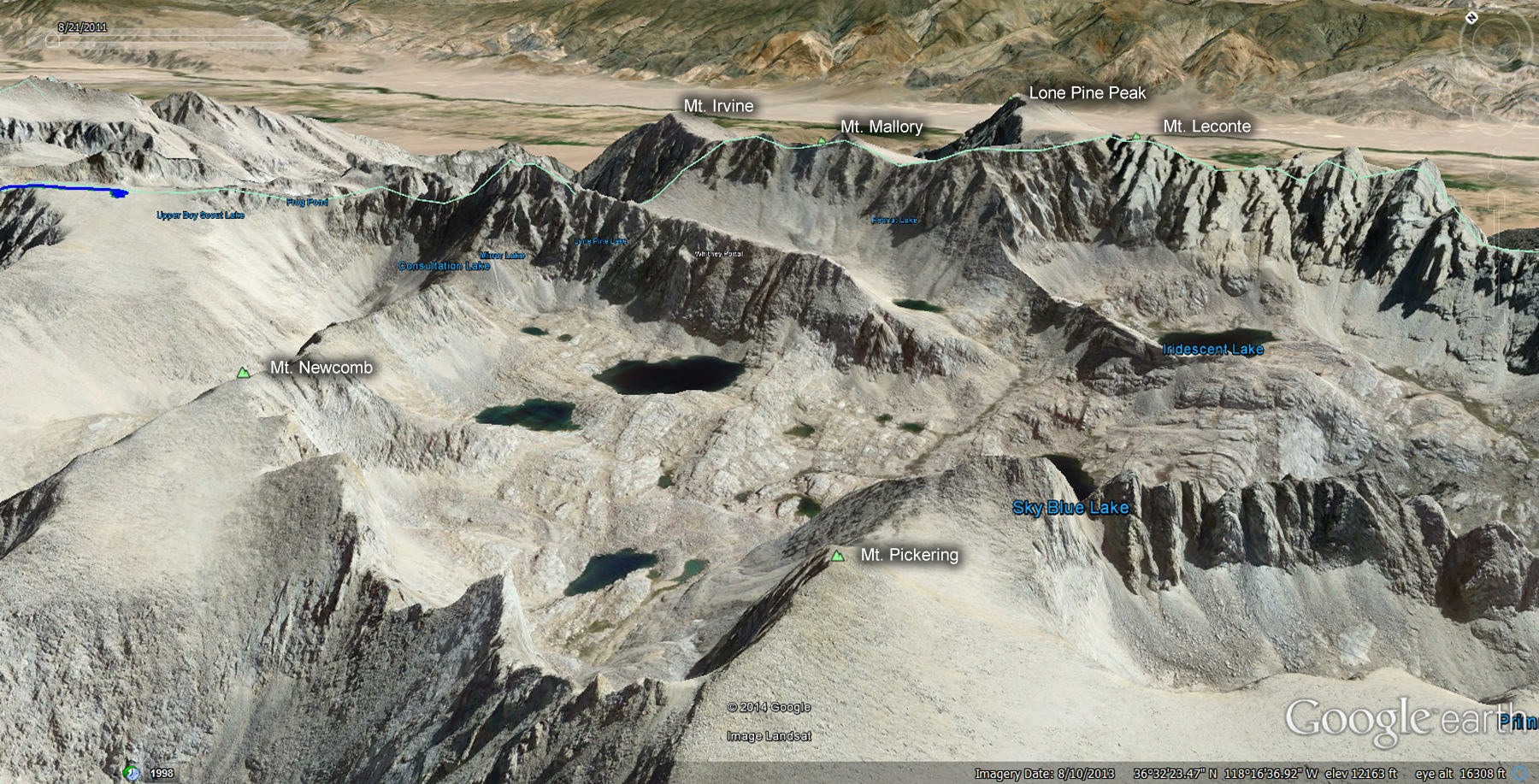
Here's my guess: The big one in the upper right is Lone Pine Peak and Mount LeConte is in front of it. Mount Corcoran is just to the right and slightly obscured by jet exhaust. Mount Mallory is covered up by the right engine but Mount Irvine is just in front of the right wing tip. Across Arc Pass and directly left of the front point of the right engine is Mount McAdie. The two lakes to the south of Crabtree Pass are just to the cockpits' right. View of the Miter is blocked by the rear half of the fuselage.
|
|
|
Re: ID the Mountains?
|
Joined: Nov 2009
Posts: 1,037 Likes: 6
|
|
Joined: Nov 2009
Posts: 1,037 Likes: 6 |
Wonder who the sled driver was?
Yep, Glenn looks correct. I will be going over Crabtree Pass with Dan a month from now, and have pored over the maps, Google Earth, and this photo. Wonderful picture, thanks Ken.
|
|
|
Re: ID the Mountains?
|
Joined: Oct 2009
Posts: 742
|
|
OP
Joined: Oct 2009
Posts: 742 |
I think that's it! I thought I had Lone Pine Peak, but the overlay of some of the peaks confused me.
|
|
|
Re: ID the Mountains?
|
Joined: Sep 2009
Posts: 8,533 Likes: 107
|
|
Joined: Sep 2009
Posts: 8,533 Likes: 107 |
Here's the picture: 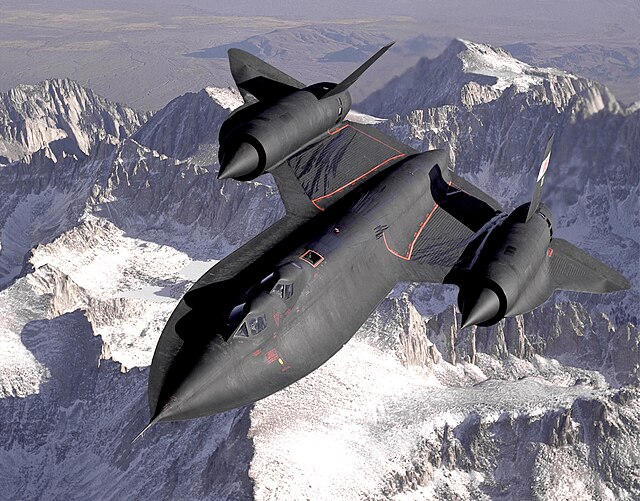
|
|
|
Re: ID the Mountains?
|
Joined: Oct 2009
Posts: 849 Likes: 4
|
|
Joined: Oct 2009
Posts: 849 Likes: 4 |
Notice the fuel leakage on the wings.
Journey well...
|
|
|
Re: ID the Mountains?
|
Joined: Nov 2009
Posts: 1,256 Likes: 2
|
|
Joined: Nov 2009
Posts: 1,256 Likes: 2 |
How weird. That same photo has been my iPad wallpaper for months. Nice to know it's the Sierra.
|
|
|
Re: ID the Mountains?
|
Joined: Nov 2009
Posts: 1,037 Likes: 6
|
|
Joined: Nov 2009
Posts: 1,037 Likes: 6 |
Gary, I have had this SR-71 book for years. It is now worth $395 ! Sled Driver
|
|
|
Re: ID the Mountains?
|
Joined: Nov 2009
Posts: 1,256 Likes: 2
|
|
Joined: Nov 2009
Posts: 1,256 Likes: 2 |
Harvey, a lot has has changed in my perceptions over my lifetime, but this was the coolest plane in the world when I was a kid, and it still is today!
|
|
|
Re: ID the Mountains?
|
Joined: Aug 2012
Posts: 671
|
|
Joined: Aug 2012
Posts: 671 |
|
|
|
Re: ID the Mountains?
|
Joined: Nov 2009
Posts: 1,256 Likes: 2
|
|
Joined: Nov 2009
Posts: 1,256 Likes: 2 |
And since that first posted shot is clearly westbound over the Sierra, maybe this is the Central Valley? Sure looks to be the same Blackbird. 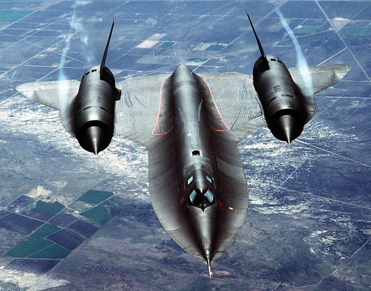
|
|
|
Re: ID the Mountains?
|
Joined: Nov 2009
Posts: 1,037 Likes: 6
|
|
Joined: Nov 2009
Posts: 1,037 Likes: 6 |
Gary , I went to Dayton, Ohio Air Force Museum to specifically see what I erroneously thought was the last flight of the SR-71, but it could not land because of high tailwinds.
To add insult to injury, I somehow did not know that the last flight would actually be nearly in my backyard - Dulles. Not only that, it broke the coast to coast speed record, and the pilot lit the purple flame afterburners for the last time when doing a flyover of the field.
Chevy - that map is a bit weird. It has the peaks, but some of the labeling is confusing. For example, right over Crabtree Pass it says Consultation Lake. That lake is not there, but over on the other side of the Sierra Crest.
|
|
|
Re: ID the Mountains?
|
Joined: Nov 2009
Posts: 1,256 Likes: 2
|
|
Joined: Nov 2009
Posts: 1,256 Likes: 2 |
Gary , I went to Dayton, Ohio Air Force Museum to specifically see what I erroneously thought was the last flight of the SR-71, but it could not land because of high tailwinds. I can relate. Twice I traveled a good distance out of my way in Florida specifically to catch a shuttle launch (one was on honeymoon). Both times the mission was postponed due to weather or technical issues. Now I'll never see one. I'll just have to live with Apollo 11 being my only in-person NASA launch. Most awesome, earth-shattering thing I've ever experienced (and that includes Deep Purple and Led Zeppelin). I've read that 45 years later down the technology road, it would be almost impossible to duplicate the Saturn V today. I so wanted to be an astronaut when I was a kid and teen. Damned calculus . . .
|
|
|
Re: ID the Mountains?
|
Joined: Jan 2014
Posts: 19
|
|
Joined: Jan 2014
Posts: 19 |
I think Harvey is correct. The peak above the notation "Consultation Lake"(which is actually Crabtree Pass) is Mt. McAdie with Mt. Marsh just to the north. Between McAdie and Irvine is Arc Pass which has Consultation Lake to its north. The plateau labeled "Upper Boy Scout Lake" is the plateau to the north of Crabtree Lakes with Discovery Pinnacle on its NW end and the Whitney trail just over the north edge.
Nice Photo.
|
|
|
Re: ID the Mountains?
|
Joined: Oct 2009
Posts: 2,251 Likes: 1
|
|
Joined: Oct 2009
Posts: 2,251 Likes: 1 |
My two favourite things SR-71 & the Sierras! The link given doesn't work, here is the parent article.
Verum audaces non gerunt indusia alba. - Ipsi dixit MCMLXXII
|
|
|
Re: ID the Mountains?
|
Joined: Oct 2009
Posts: 742
|
|
OP
Joined: Oct 2009
Posts: 742 |
Talk about a wasted opportunity: When I was about 13, I visited my uncle Bob, who was the deputy commander of Edwards AFB. One day, he took me down to the flight light on the weekend. We went into this hanger that contained the X-15 and the XB-70, both of which I climbed up upon and looked at. I don't remember seeing anyone else there. It wasn't until decades later that I came to the realization of what that trip really was. Oddly, no Russians have ever asked me about it.  I also attended the launch of Apollo 13, and it was exactly as described. I remember it well, and remember that VP Agnew was in attendance.
|
|
|
Re: ID the Mountains?
|
Joined: Nov 2009
Posts: 1,256 Likes: 2
|
|
Joined: Nov 2009
Posts: 1,256 Likes: 2 |
I may be mistaken, but I think Neil Armstrong also piloted the X-15 a time or two before joining NASA. Those were some heady days. I read Neil DeGrasse Tyson's Space Chronicles a few weeks ago, which stirred up that same sense of wonder I used to feel about the space program. Those days may not be gone forever, but they're certainly not in our near future.
|
|
|
Re: ID the Mountains?
|
Joined: Nov 2009
Posts: 1,037 Likes: 6
|
|
Joined: Nov 2009
Posts: 1,037 Likes: 6 |
I may be mistaken, but I think Neil Armstrong also piloted the X-15 a time or two Seven ole Neil pulled an even strain. That Schirraism is in here somewhere - not about Neil specifically, but about test pilots keeping their cool Right Stuff
|
|
|
Re: ID the Mountains?
|
Joined: Oct 2009
Posts: 849 Likes: 4
|
|
Joined: Oct 2009
Posts: 849 Likes: 4 |
I do not see a "buno" to positive ID....
To think the SR-71 was actually named RS-71, but LBJ got it backwards...
And to think it was built using a "slide ruler."
When I was on Okinawa, I had a chance to see them land and take off from Kadena Air Force Base back in the early 70s.
Their profile from the front and back was absolutely awesome.
Journey well...
|
|
|
Re: ID the Mountains?
|
Joined: Nov 2009
Posts: 1,256 Likes: 2
|
|
Joined: Nov 2009
Posts: 1,256 Likes: 2 |
I do not see a "buno" to positive ID.... Gary, I was really going off of the fuel streaks on the fuselage and wings. It appears both photos were taken from a refueling tanker. There appears to be a designation on the tail in Ken's photo, but the other shot is head-on so no way to confirm. It seemed possible the shot I posted might be a continuation of that same flight, but I'm no expert on the San Joaquin. Hell, the times I've been up there the air was so bad I couldn't see squat.
|
|
|
|
|