Is there a statute of limitations for posting a trip report on the WZ? Anyway, last September I was fortunate enough to have two Sierra trips but I didn't find the time to post until now.
First was a trip to the Pioneer Basin via Mosquito Flats and Mono Pass from Sept. 3 to 8.
I flew to Las Vegas where I met-up with a friend who flew in from North Carolina. We drove to the Campground near the Bristlecone Pines to rendezvous with the third member of our group who drove from the Bay Area. On the way we stopped at Mel's Diner in Beatty, NV, for an early dinner. Mel's is fine but I really miss the Ensenada Grill which used to be in that location.
Camping there the first night at ~8000' is a good way to start adjusting to the altitude. The next morning we hiked the Methuselah Trail loop at 10,000' to continue our acclimatization and then drove to Bishop to get our permit, have dinner at Taqueria Las Palmas, and stay the night.
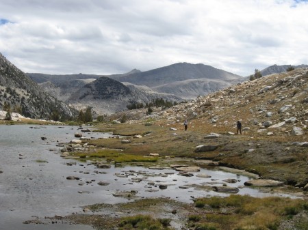
Day 1: The hike to Pioneer Basin can be done in one day, but why hurry? We hiked in on the Mono Pass trail and camped overnight at Trail Lakes. It's only about a 5 or 6 mile hike but we took our time enjoying the great scenery and stopping to chat with other hikers.
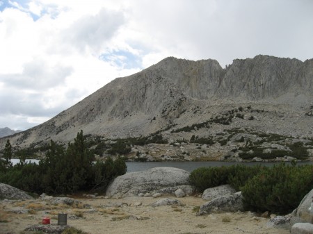
Day 2: From Trail Lakes the trail drops down to Golden Creek (which feeds Mono Creek) and within about a half mile from there the Pioneer Basin trail branches up to the north. In the past I've thought of the Pioneer Basin trail as a use trail, but it shows on the Tom Harrison Mono Divide High Country map as a maintained trail, and it is easy to follow. Two miles of hiking up from Golden Creek, the trail hits Lake 10,862 in the heart of Pioneer Basin. A short distance north along the shore is where we set-up camp on a low bluff overlooking the lake. The campsite was complete with above treeline-style windblown stunted trees, a variety of rocks to sit on and lean against, and a sandy base.
Passing by a small lake along the Pioneer Basin trail, not far from Lake 10,862 in the heart of the basin.
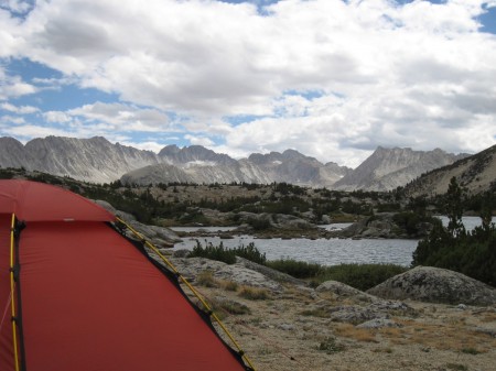
View toward Third Recess and Fourth Recess from camp at Lake 10,862. This view alone is a good reason to visit the Pioneer Basin.
Day 3: We got up early enough to catch the sunrise as we left camp to trudge up Mount Hopkins (12,304'). I say “trudge” because a large part of the climb is up a steep sand hill – tedious if you're not in the mood, mesmerizing if you are. The views from the top in the direction of Red and White Mountain are spectacular with the colored metamorphic bands contrasting with the usual Sierra soft gray granite views. Descending back to camp on the sand/gravel slope was as much fun as it should be, although we inadvertently took a slightly different route than we had come up and had to carefully work our way around some steeper rock sections.
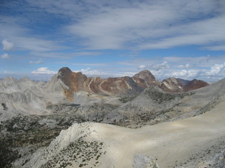
Red and White Mountain (left) and Red Slate Mountain (right) as seen from the summit of Mount Hopkins.
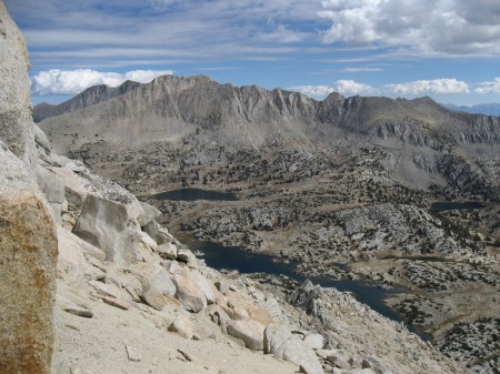
View across the Pioneer Basin from the east flank of Mount Hopkins. Mount Stanford is on the skyline left of center and Lake 10,862 is in the foreground. Camp was on the opposite shore left of the two small islands.
Mount Hopkins viewed from camp at Lake 10,862. Our route to the top followed along the left-hand side.
Day 4: Another early start for a day-hike, this time to climb to the saddle at the head of the basin and then up Mount Stanford (12,838'). (One might get the impression that these peaks were named after universities, but rather, they were named after railroad barons. In the case of Mount Stanford, though, this peak was named for the same man as the university and the peak named for the university itself is located near the head of the upper Kern Basin. I guess mountain names are like that.) From the saddle the route part way to the top is straightforward but then turns to class 2 scrambling and some route finding along the side of the summit ridge. There were blowing clouds and strong winds that day to make it all the more exciting.

Saddle at the head of Pioneer Basin as viewed from somewhere below the summit of Mount Stanford.
Day 5: Our original plan was to stay at Lake 10,862 in the Pioneer Basin on Day 5 and then hike out all in one day, but we became curious to check-out Golden Lake, up near the pass and off the main route on a side trail. Except for the two-mile Pioneer Basin trail, the main route that we came in on is very heavily used and we wondered if the route via Golden Lake, with a short x-country segment to connect to Mono Pass, would be more enjoyable. We were not disappointed. Camping the night at Golden Lake was very nice and it became our preferred route to the Pioneer Basin from Mosquito Flat. The x-country segment, partly on use trail, was easy and straightforward.
Day 6: I always like the last day of a backpacking trip, not only because the hiking tends to be downhill, but also because that's when I start thinking about things like a shower, a good meal, and the comforts of home. I can also reflect on how much fun it was to be playing in the mountains on the preceding several days. We hiked out, drove to Bishop, got cleaned-up, had dinner at Taqueria Las Palmas, and stayed the night.
Dinners on the trail? For me, I won't go backpacking without at least one night of MaryJanesFarm Organic Chilimac and one night of Enertia Trail Foods Moosilauke Goulash. Other than that, some Beef Stroganoff (the all-time classic) is usually on the menu for one night, as it was on this trip.
This was my second trip to the Pioneer Basin and I'm sure it won't be the last. The constant views looking south down the basin toward the Recesses are spectacular, and there are plenty of day-hike opportunities and peaks to scramble up.


