|
0 members (),
49
guests, and
26
robots. |
|
Key:
Admin,
Global Mod,
Mod
|
|
 Onion Valley Peaks Last Weekend
|
Joined: Nov 2009
Posts: 10
|
OP

Joined: Nov 2009
Posts: 10 |
Last weekend I climbed Independence Peak and University Peak. Here is the trip report: Getting Schooled on University Peak
|
|
|
Re: Onion Valley Peaks Last Weekend
|
Joined: Sep 2009
Posts: 660
|
|
Joined: Sep 2009
Posts: 660 |
Thanks for the TR Sam.Good job sounds like it was a tough week out there for everyone.Wind,ice snow have made it tough going.Nice to know you hardy types are still getting at it.I'm waiting for a Sierra spring to get out again.
|
|
|
Re: Onion Valley Peaks Last Weekend
|
Joined: Sep 2009
Posts: 8,533 Likes: 107
|
|
Joined: Sep 2009
Posts: 8,533 Likes: 107 |
Nice report Sam. Thanks for posting.
It would be nice to see a map with your route traced on it.
|
|
|
Re: Onion Valley Peaks Last Weekend
|
Joined: Nov 2009
Posts: 10
|
|
OP
Joined: Nov 2009
Posts: 10 |
It would be nice to see a map with your route traced on it. Ask and you shall receive: Map from Bob Burd's website
|
|
|
Re: Onion Valley Peaks Last Weekend
|
Joined: Sep 2009
Posts: 8,533 Likes: 107
|
|
Joined: Sep 2009
Posts: 8,533 Likes: 107 |
That is a very good map, Sam. I enjoy looking at maps like that and noting the contour density to get an idea of the steepness of the climb. Also, I was trying to hint that your article would be more complete if a map were included there, too  .
|
|
|
Re: Onion Valley Peaks Last Weekend
|
Joined: Nov 2009
Posts: 40
|
|
Joined: Nov 2009
Posts: 40 |
Very nice trip report - your doing a nice job with your blog.
I also think route maps like Bob Burd has with his reports and pictures are really nice. I use people's trip reports to get ideas for future hikes and scrambles up mountains and it's a big help when there's a map of the route with the report. I've been trying to include a map of my route with my pictures from my trips on my Smugmug site because I figure if I'm using maps I find with other people's reports, I should give back by posting maps for others to use.
|
|
|
Re: Onion Valley Peaks Last Weekend
|
Joined: Nov 2009
Posts: 10
|
|
OP
Joined: Nov 2009
Posts: 10 |
Glad everyone likes my trip report.  Now, about the maps. Where is the best place to get free images of maps that can be saved and scribbled on?
|
|
|
Re: Onion Valley Peaks Last Weekend
|
Joined: Sep 2009
Posts: 8,533 Likes: 107
|
|
Joined: Sep 2009
Posts: 8,533 Likes: 107 |
Sam, you can use Topozone.com or Google Maps. Once you display the area you want, you then need an image capture application (I like Snagit) to grab the image and save it as a .jpg. Once you've done that, you can use a picture drawing tool to edit the image and add lines or labels. I've used the Paint software on Windows for that.
Unfortunately, it takes some time to create a good map image and add your features.
|
|
|
Re: Onion Valley Peaks Last Weekend
|
Joined: Nov 2009
Posts: 40
|
|
Joined: Nov 2009
Posts: 40 |
It's a lot easier to use software like National Geographic TOPO or Terrain Navigator than the frees maps that are out there, but it'll cost you a little to buy the software.
TOPO is down to $70 per state: http://shop.nationalgeographic.com/ngs/product/maps/software/topo!-california
National Geographic also has an online version but I've not enjoyed using it.
|
|
|
Re: Onion Valley Peaks Last Weekend
|
Joined: Nov 2009
Posts: 10
|
|
OP
Joined: Nov 2009
Posts: 10 |
At long last, here is my route diagram for the North Couloir on University Peak: 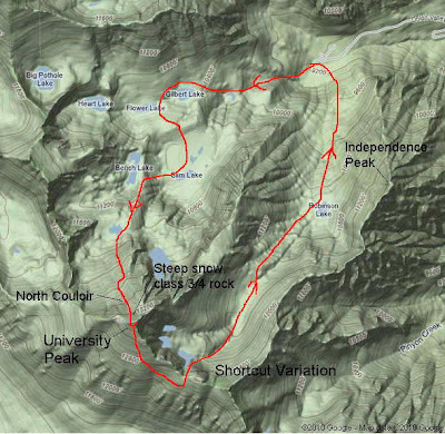 Here is the full-size image Here is the full-size image
|
|
|
Re: Onion Valley Peaks Last Weekend
|
Joined: Sep 2009
Posts: 8,533 Likes: 107
|
|
Joined: Sep 2009
Posts: 8,533 Likes: 107 |
Good image, Sam. Thanks for posting it.
|
|
|
Re: Onion Valley Peaks Last Weekend
|
Joined: Nov 2009
Posts: 10
|
|
OP
Joined: Nov 2009
Posts: 10 |
Thanks Steve. And since you were so quick to respond, here is more: 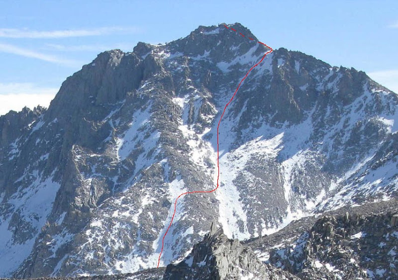 Photo by Craig Jackson
|
|
|
|
|


