|
0 members (),
41
guests, and
8
robots. |
|
Key:
Admin,
Global Mod,
Mod
|
|
 Half Dome From Turlock-The Final Chapter
|
Joined: Nov 2009
Posts: 215
|
OP

Joined: Nov 2009
Posts: 215 |
If it's good enough for the US Government: 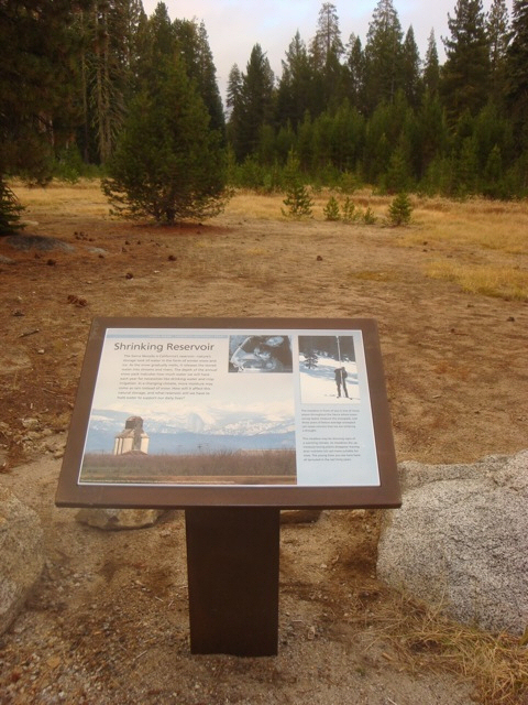 (the famous controversial Half Dome from Denair: 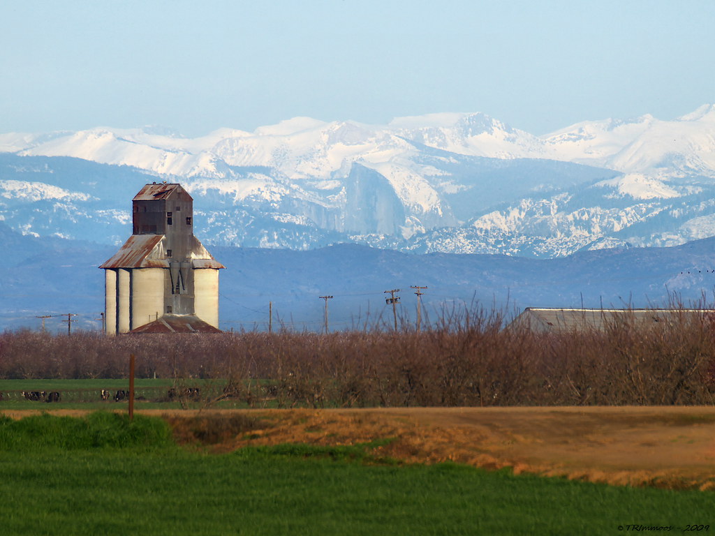
Mike
|
|
|
 Re: Half Dome From Turlock-The Final Chapter
|
Joined: Sep 2009
Posts: 8,533 Likes: 107
|

Joined: Sep 2009
Posts: 8,533 Likes: 107 |
Wow, Mike! Where is that "Shrinking Reservoir" sign? I sure hope Tony Immoos got credit! Edit: Mike has some good links here on YosemiteNews.info: Half Dome From Turlock: The Final ChapterEdit: Here's some more information, including a note from Tony. Click on Tony's link to see two images with some of the text from the sign. Yosemite signage After waiting all summer I finally got word that the display featuring my image of Half Dome from Denair has been installed along Tioga Road at Gin Flat, it's about 4 miles east of Big Oak Flat road junction. It's a pretty boring turnout on the south side of the road with out any exciting vistas so it probably won't get a lot of views but it's there and will be for years to come so I'm pretty excited. http://www.flickr.com/photos/trimmoos/5140249246/ By the way, last Friday (Oct 29, 2010), the air was crystal clear in the San Joaquin Valley, and I was thinking it would be nice to go see that view again.
|
|
|
 Half Dome From Denair CA
|
Joined: Sep 2009
Posts: 8,533 Likes: 107
|

Joined: Sep 2009
Posts: 8,533 Likes: 107 |
I think it is time to re-post the original to this forum. The following was posted on wpsmb March 18, 2009. It created quite a stir at the time.
About a month ago, photographer Tony Immoos from Sacramento got wind of views into Yosemite from the Central Valley floor, and went looking to get a picture. Below is his picture. The picture got me pretty excited because I have driven by the grain elevator dozens of times (on Montpelier Road), and because I grew up a few miles from there. Click on the image for full size (1.5 MB).  Tony's image and write-up is here: On The Outside Looking In. Tony also posted a four-photo composite panorama taken from the same place (Click on the image for full size 1.3 MB).  Tony's image and write-up is here: Yosemite NP and Half Dome from Denair, CA. So, with all my excitement, I emailed Wayne from this board, and with his help, created an annotated version of the panorama. I posted it on SummitPost, and people pointed out some mistakes. Then Mike C from Las Vegas posted his program-generated view. At first, I did not appreciate the significance, but I emailed him asking about his "program". It turns out he has spent hundreds of hours creating the program to process USGS data and create the most incredible simulated views. Not only that, but he can then use his view to pinpoint the geographic location of each peak in the display. Here is his computer-generated view of the first picture:  And here is the result of all the help I got from both Wayne and Mike: (Click for full-size, 320 KB).  By the way, if you are driving on the 99, that view lines up in Turlock just south of the Monte Vista Avenue (Stanislaus State University) exit. But there are very few days when it is clear enough to see that far. Edit 4/4/09: Yesterday I had the opportunity to stop by the camera site, to see what I could see. While it was nearly clear enough, there were clouds in the Yosemite area so I didn't see the famous view. But I was impressed with this: That picture is phenomenal! I held out my arm as far as possible, and using my thumb, tried to measure the width of the view. Note the first picture above. I could see the grain elevator and the roof of that big shed to its right. They look tiny -- the ARE a mile and a half away. And my thumb HID THE ENTIRE WIDTH OF THAT PICTURE!!! -- from grain elevator to entire width of the shed's roof. If I could have seen Half Dome, it would have been visible through the eye of a safety pin at arm's length! Update April 2010: Mike Condron visited the camera site and got a video of the same scene.
|
|
|
 Re: Half Dome From Denair CA
|
Joined: Sep 2009
Posts: 8,533 Likes: 107
|

Joined: Sep 2009
Posts: 8,533 Likes: 107 |
The pictures really grabbed my interest, so I created some maps in Google with lines to the peaks in the pictures above. Originally posted 3-18-09: Link to an artist view of the Yosemite area: http://www.freebase.com/api/trans/raw/wikipedia/images/commons_id/2611816Also, it is pretty tough to refute the computer-generated image. It was generated by giving the location coordinates of the camera and then running the program using USGS elevation/location data. Compare the generated image with the one at the top. Also, I forgot to post the Google Map view that I used to help me ID the peaks. Here are several views (click on each one for the full size), or click this link to actually go into Google Maps and play with the map yourself.   You can view my smugmug gallery here. More links--
|
|
|
 Half Dome From Turlock CA
|
Joined: Sep 2009
Posts: 8,533 Likes: 107
|

Joined: Sep 2009
Posts: 8,533 Likes: 107 |
Today, I got a rare chance to see if one could see Half Dome from Hwy 99 in Turlock. It was one of those crystal-clear days following a big storm that passed through last night. AND, I was driving through Turlock on Freeway 99. Having worked on the maps and lines posted above, I knew the line crossed through the northern part of Turlock, crossing the 99 at about Monte Vista Ave. So we stopped -- on the freeway shoulder with cars whizzing by -- and I got the pictures below. On the side of Freeway 99.  Approximately what I could see with naked eye:  Zoomed in at 16x  This picture is a crop of the above picture:  All the pictures are in my Smugmug album: Half Dome from Denair
|
|
|
 Re: Half Dome From Turlock CA
|
Joined: Oct 2009
Posts: 849 Likes: 4
|

Joined: Oct 2009
Posts: 849 Likes: 4 |
Well, I'll be...
I hereby recant any doubt on my behalf.
Amazing...
Have fun...
Journey well...
|
|
|
 Re: Half Dome From Turlock CA
|
Joined: Sep 2009
Posts: 660
|

Joined: Sep 2009
Posts: 660 |
Nuff said. Proven to be true by our own Steve C.
|
|
|
 Re: Half Dome From Turlock CA
|
Joined: Sep 2009
Posts: 8,533 Likes: 107
|

Joined: Sep 2009
Posts: 8,533 Likes: 107 |
Tony Immoos sent me links to a nice map he created by using a handy map tool at HeyWhatsThat.com (aka HWT) See it yourself: Half Dome on HWT. Tony's flickr page is here: Half Dome Viewing AreaHere's his map created using the "Visibility Cloak" feature on the HWT. 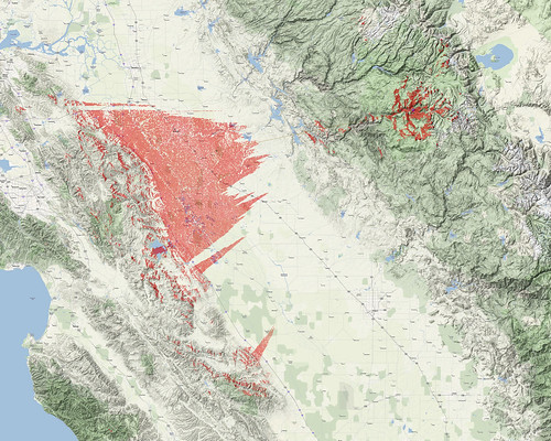 Click on the picture for the huge view. Here's how Tony created the big map: So what I did was zoom back in a bit to get some detail, then I made a screen capture of the map, moved it and made another, and another and another.... I then pieced them together in Paint Shop Pro like a puzzle and came up with a 5000x4000 pixel map showing all the places you could see HD from. Thank you, Tony!!! I did not know about HeyWhatsThat.com until now. It's a great site -- should be handy for generating some nice profiles and maps.
|
|
|
 Re: Half Dome From Turlock CA
|
Joined: Sep 2009
Posts: 8,533 Likes: 107
|

Joined: Sep 2009
Posts: 8,533 Likes: 107 |
More interesting views... Here is a picture showing Half Dome taken from Dewey Point, which is a few miles west of Half Dome on the rim of Yosemite Valley.  And this picture is taken from the same point, looking west toward the coast range. The two peaks are Mt Isabel and Mt. Hamilton, above San Jose, 112 miles away!  The pictures above got me to looking around, and I found the image below from Viewfinder Panoramas (see gallery, Copernicus Peak) The image is taken from Copernicus Peak on Mt. Hamilton. Here is the annotated view from Copernicus. In the annotated view, Half Dome is not identified, but it is obvious between and below "Kuna" and "Parsons". If you view the Original size version of this picture, see if you can spot Half Dome--It's a little right of center. (click on the image to see the original size)  Here is the same photo, annotated by Wayne Pyle:  And finally, this is a crop taken from the full-size view of the picture above. It's width takes in the same peaks shown in the original picture of the grain elevator taken by Tony Immoos from Denair. 
|
|
|
 Re: Half Dome From Turlock CA
|
Joined: Aug 2010
Posts: 40
|

Joined: Aug 2010
Posts: 40 |
My family lives in Salida, I can't wait to keep my eyes peeled my next trip home!
|
|
|
 Re: Half Dome From Turlock-The Final Chapter
|
Joined: Sep 2009
Posts: 8,533 Likes: 107
|

Joined: Sep 2009
Posts: 8,533 Likes: 107 |
I stopped by the sign and snapped a picture Jan 1, 2012. Dry conditions this year really underscores the message on the sign. (The sign is about 4 miles east of Crane Flat on Tioga Road in Yosemite.) 
|
|
|
 Re: Half Dome From Denair CA
|
Joined: Oct 2011
Posts: 21
|

Joined: Oct 2011
Posts: 21 |
This entire thread is really, really interesting! Thanks so much for posting this.
|
|
|
 Re: Half Dome From Denair CA
|
Joined: Sep 2009
Posts: 8,533 Likes: 107
|

Joined: Sep 2009
Posts: 8,533 Likes: 107 |
Sheldon Neill of " Yosemite HD Timelapse Video" fame took this shot from the top of Half Dome. The lights of the Central Valley are in full view. 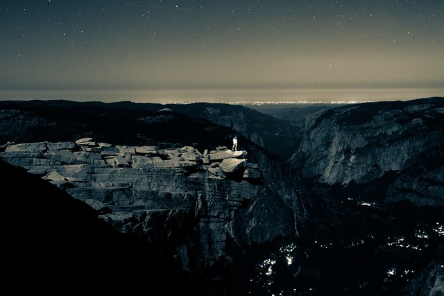 This picture is found here.
|
|
|
 Re: Half Dome From Denair CA
|
Joined: Jan 2010
Posts: 1,034
|

Joined: Jan 2010
Posts: 1,034 |
hmm - I thought no overnight use of Half Dome, last time I checked...  so all you gotta do is "we're taking some night photos" and you're still ok to spend the night up there? Or you have to get your butt down before midnight? Probably a matter of "who's gonna check?" Main reason I have not been back to Half Dome in now over 20 years is the above sign. The last time I was up there we did spend the night, almost alone.
|
|
|
 Re: Half Dome From Denair CA
|
Joined: Feb 2012
Posts: 3
|

Joined: Feb 2012
Posts: 3 |
The permitting rangers are random and some shifts are at night.
You can walk around up there at night but you cannot set up camp.
|
|
|
 Re: Half Dome From Denair CA
|
Joined: Sep 2009
Posts: 8,533 Likes: 107
|

Joined: Sep 2009
Posts: 8,533 Likes: 107 |
> You can walk around up there at night but you cannot set up camp.
'Zactly. A local Sierra Club hike leader in the past led annual midnight hikes: watch the sunrise, then exit. He related how the park people phoned him and reminded him there was no camping. He insisted they weren't camping. If you're up there without bedding or a tent, you're not camping.
|
|
|
 Re: Half Dome From Denair CA
|
Joined: Jan 2010
Posts: 1,034
|

Joined: Jan 2010
Posts: 1,034 |
ah yes, creative rule interpretation. The sign doesn't say "overnight stay" after all 
|
|
|
 Re: Half Dome From Denair CA
|
Joined: Nov 2009
Posts: 56
|

Joined: Nov 2009
Posts: 56 |
> You can walk around up there at night but you cannot set up camp.
'Zactly. A local Sierra Club hike leader in the past led annual midnight hikes: watch the sunrise, then exit. He related how the park people phoned him and reminded him there was no camping. He insisted they weren't camping. If you're up there without bedding or a tent, you're not camping. What if you're up there, no food, no stove, no tent, you have a wilderness permit, your main camp is down by the junction, but you're inside a sleeping bag so you don't freeze to death, and sleeping next to a camera that's taking an 8 hour time-lapse of the milky way?
Last edited by Joel M. Baldwin; 02/27/12 09:17 AM.
|
|
|
 Re: Half Dome From Denair CA
|
Joined: Aug 2011
Posts: 22
|

Joined: Aug 2011
Posts: 22 |
Man, this sounds too familiar.  We left the majority of our gear at our campsite in 'Little Yosemite Valley' but like everyone's stated above, as long as there's no camping, you're fine. We were up there from 6PM to about 11AM the following day. We didn't sleep, but we ate food occasionally and looked up at the stars while we watched our timelapses finish. We had our sleeping bags--just in case--it got too cold, but at some point I even took off my jacket because it was so nice. When you get shots like this, its totally worth it: 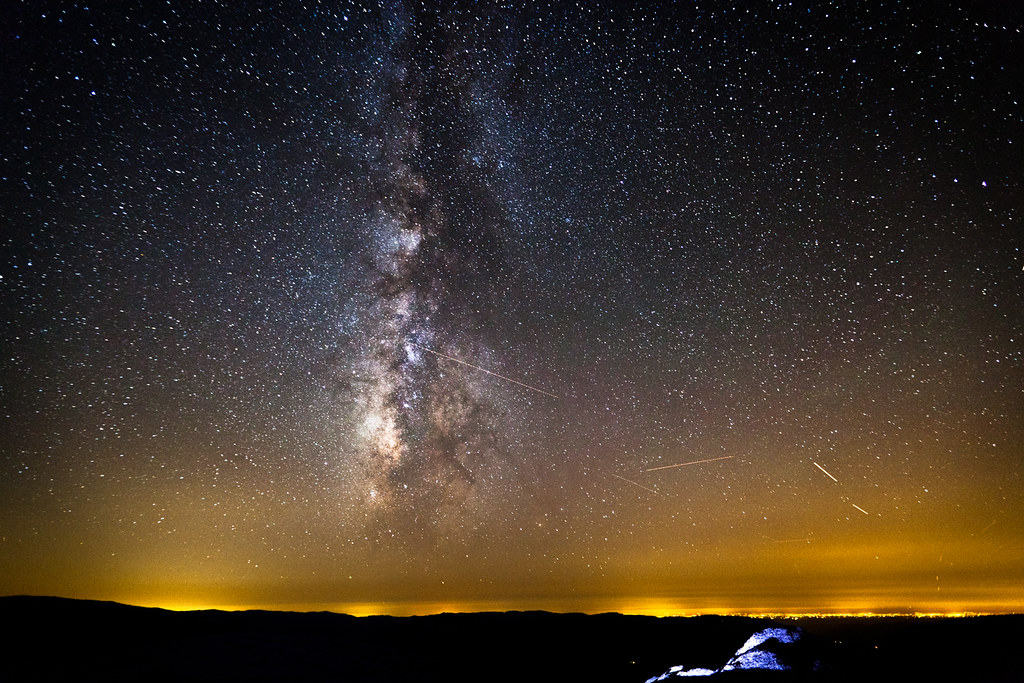 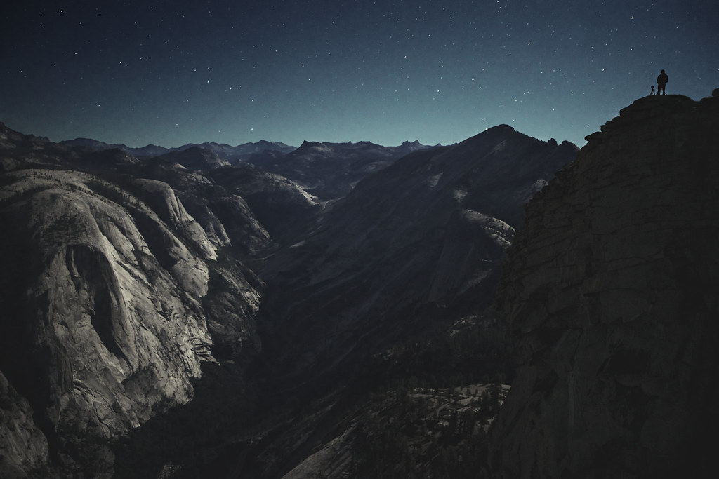  We were up on the summit of half-dome alone for about 12 hours. It wasn't until sunrise we actually had some visitors. However we later had a ranger come up the cables because there was a death from a climber who fell when reaching for the 7th pitch on the north visor--which Colin and I witnessed, and had a radio to listen in on. The chilling part is that same ranger--Ryan Hiller btw--that had us fill out a witness report, and tell him what all our camera gear was for--was killed a day after our Yosemite HD release. You can ready the story and see a photo with him(in August the day before we did our timelapses on half-dome) and us here:  http://latimesblogs.latimes.com/lanow/20...ters-state.html http://latimesblogs.latimes.com/lanow/20...ters-state.html It gives me the chills thinking about it, but to keep it simple, if you ever plan on doing something like this, realize the risk and danger involved. Be aware of weather--we were up when we had clear skies for a whole weekend--and have plenty of water. Its kinda odd that no one caught on that we did this, but then again, I'm just now seeing this. Too funny.
|
|
|
 Re: Half Dome From Denair CA
|
Joined: Nov 2009
Posts: 215
|
OP

Joined: Nov 2009
Posts: 215 |
Man, this sounds too familiar.  We left the majority of our gear at our campsite in 'Little Yosemite Valley' but like everyone's stated above, as long as there's no camping, you're fine. We were up there from 6PM to about 11AM the following day. We didn't sleep, but we ate food occasionally and looked up at the stars while we watched our timelapses finish. We had our sleeping bags--just in case--it got too cold, but at some point I even took off my jacket because it was so nice. When you get shots like this, its totally worth it:  [img:center] http://farm8.staticflickr.com/7160/6732523683_d426decdaf_b.jpg[/img]  We were up on the summit of half-dome alone for about 12 hours. It wasn't until sunrise we actually had some visitors. However we later had a ranger come up the cables because there was a death from a climber who fell when reaching for the 7th pitch on the north visor--which Colin and I witnessed, and had a radio to listen in on. The chilling part is that same ranger--Ryan Hiller btw--that had us fill out a witness report, and tell him what all our camera gear was for--was killed a day after our Yosemite HD release. You can ready the story and see a photo with him(in August the day before we did our timelapses on half-dome) and us here:  http://latimesblogs.latimes.com/lanow/20...ters-state.html http://latimesblogs.latimes.com/lanow/20...ters-state.html It gives me the chills thinking about it, but to keep it simple, if you ever plan on doing something like this, realize the risk and danger involved. Be aware of weather--we were up when we had clear skies for a whole weekend--and have plenty of water. Its kinda odd that no one caught on that we did this, but then again, I'm just now seeing this. Too funny. What photography permits from the NPS hoops did you guys have to go through?
Mike
|
|
|
|
|