First I want to thank Steve and John and everyone who answered my questions about the mountain conditions and preparations. English is not my first language so apologize if I'm not clear.
This report will focus on the preparation of a MR hike. It's my personal opinion and I hope it can help future hikers!
1. The Permit.I didn't have a permit and I needed 5 for my group. My target date is 9/21/2013, the 3rd Saturday in September. According to historical data I'd be ok, but weekends are not sure. What happened was I was able to buy 3 permits a week prior the date by checking the online system 3 times a day. I paid $51 total for those 3 permits. I needed 2 more.
So when I was driving to Lone Pine from SFO on Friday morning, I received an email at 1:45PM, saying that I am a noshow!! What?? I immediately called the office and they said they thought I would be a no show because I didn't confirm. So that's what the confirm means, I guess you must call them and tell them that you WILL be picking up the permits. They are very helpful and I told them I am 10 minutes away. I arrived at 1:55PM at the ranger station and just barely got my 3 reserved permits, and there are a bunch of people waiting for free permits. We had 21 at that point (day permits). This is what happened, we are asked to have 1 person per group to do a lottery to decide our order. We had 5 groups for 21 permits, so it should be good as long as the 1st group doesn't take all 21 permits. We were number 2 and we got 2 free permits and I think everyone got theirs too. BUT, it you arrive later than 2pm for freebies, I'm not sure how many will be left.
By the way our permits were not checked during our hike.
The Start:
You should rest well, and you can rent a room at the mt. whitney hostel for like $90, you shouldn't rent a bed because you can't sleep. It's 25 minutes from the hostel to the trailhead. And for a fit hiking team, you should still start at about 4am, that's what I planned for. For special reasons we started at 5am. I knew it was late.
2. The Route to E-ledge.So the thing is you definitely do need to check out the route that led to the ledge if you haven't hiked this before. After we grabbed our permit, we headed to the trailhead and it took us just about 1hr 15 minutes to get on the ledge and walked to the turn up point. This will give you confidence because you will be hiking in the dark for this part. And it's not exactly straight forward.
Here it is: cross one stream, right before you reach another stream (about 20 minutes), you see a sign said "North Fork Lone Pine Creek", and now you look to your right and there's a sort of faint trail lead uphill. You take it. You go uphill, when you saw giant rock wall to your right the first time, you ignore it, the second time it appears to your left, you ignore it and follow the trail to go right. You MUST cross stream twice again! And then you'll see it. It looks just like on the internet, pretty straightforward. So you start the climb right after you pass the stream the second time, after that it's easy.
The part from the lone pine sign to the beginning of the ledge is what you need to check, so you can easily do this in the dark.
3. The E-ledgeYou've all seen it, it's really not bad. Nope. Of course, don't fall. But the ledge is not that narrow. When you turn back up to the left, remember to go all the way to the top of the edge when you can touch the rock wall and then you have 0 exposure, and you have a trail. There is also another trail in the middle that goes left and I took that one myself a little bit. I think that was the old trail. After maybe 30 minutes you arrive at the lower boyscott lake, there is pretty much no chance you'll get lost. It's all trails.
4. Lower Lake to Upper LakeAgain you've all seen this below image, target the two giant boulders and really, really stay low, the trail is immediately to the right of the smaller boulder that is lower.
Once you gained the giant slab, you will be walking on the slabs for a bit, here you navigate by looking for cairns, and it's generally not too bad, you stay close to the lone pine creek, go left, right a little bit, drink some water, and generally go up. And after maybe 1 hour you will see another lake, the upper lake. You stop as soon as you see the lake, because this is the time you turn left (south). You don't get to the lake.

 5. Upper Lake to Iceberg Lake.
As you turn left (south), you start to go uphill, and you can't see Mt. Whitney for a while because you are trying to go around this plateau and find a chance to climb it. Good thing is that there is a trail to follow. This part is more difficult than the previous part. It's just a lot of climb. When you go for another 1 hour, you are getting closer to the mountain. And you just know it's time to climb back up to your right, you need to gain that plateau. This is hands on climbing and there is not exactly a trail to follow, but the rocks are solid and the climb is short, you will gain the plateau easily and there is Mt. Whitney and the iceberg lake.
6. The Iceberg Lake to the Notch.
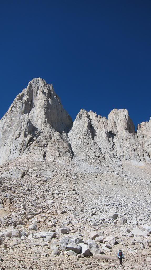
Walk the 3 minutes to the lake and drink water and eat. In reality, the colouir looks steep than it appears on the photo. And when you climb it, it also feels steeper. The steepest part is the upper part of the colouir where you generally turn right to try to gain the notch. Our phone GPS recorded 43 degrees (87%). So the colouir is pretty straightforward, it's right there. Even a slight trail leading up to it. Not too bad. We took the main colouir, not the one to the left (appears to be the other side of the triangle). The reason is the main colouir seems to be less steep (we know the rocks are bad). I launched a pretty big rock down and you definitely need to stay close and wear helmets. As you climb up to the point where you turn right generally, you look back and you realize it's really steep. And it gets steeper from here. There is no trail and I encountered a choke point just about at the middle of the colouir. It can be climbed around to your right. So that's the really steep part. And the rocks are generally getting a little better as you go up higher. It took us 3 hours to climb this colouir (we were waiting for one slower member) to get to the notch.
 7. The Notch to the Top via the final 400.
At this point, it's like 2:15pm. It's not what I'd like (I planned to be on top by 1pm), but at this point you can only go up. So the final 400 is very straightforward, doesn't look too bad. At this point we met a group of hikers returning from the 'traverse', I asked them about the condition, because I heard it was really slippery and bad, they said it was ok and that was also the way they took up. I looked at my team and we decided to take the final 400. It's really short.
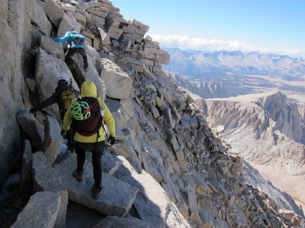
So we start the climb, which is the most difficult part. But really, if you have team members, they can help you and it's no problem. (knowing that you don't have to down climb, of course) After the initial part, we stayed generally to the left, as recommended. There were only two icy spots in the middle. So we didn't take the middle. Just a little bit, not extremely, to the left. And you go, and go, and you find a part where you can't go directly up anymore because it's almost vertical. You look to your right and you realized you have to make a lateral move and that's it. This lateral move is interesting. It's a very narrow ledge. One of my team member does rock climbing, so she climbed directly up to the ledge and then moved to the right. I stayed to the left and made a super awkward move to the right on the ledge. This is technically the most difficult part and you can't fall. I don't think you would, if you take your time. But if there is ice here, I'd have to abandon the hike. Or maybe even just have to down climb this, I'd also have to abandon the hike. Our route appears to be exactly the red line (easiest line) in Bob's route report. It's pretty natural.
The below picture is right after that lateral move, you are ready to gain the summit, easily.
 8. The 11 miles back.
Sot it's 3pm when we summited! So late! Oh well, it took us another 7 hours to get back to the trailhead. The thing about Mt. Whitney trail is that it has so many switchbacks, and you don't lose elevation in the first 2-3 miles, you actually gain some more. We also had gust to 65mph and you get cold quickly. All you can do is to get as low as possible before it's completely dark. We got back down to the trail camp when it's almost dark. And the trail is not that easy to follow, that's why you need to start early to avoid this kind of situation. After the 99 switchbacks to the trail camp. you go down and I think you have another 200 switchbacks, it was worse than the 99 switchbacks, for sure. We got back at the car at 10:15pm, making it a 17 hour hike.
 9. The altitude sickness, drive from Bay Area.
We didn't feel much altitude but we did go very slowly... I took one advil at the lower lake and I didn't feel a thing later. I had altitude sickness when I was climbing Mt. Elbert in Colorado.
I took 108 cross Yosemite and I regretted it. I should've taken the 120, or the I-5 to go south and go through Bakersfield, which is our way back. It was easy driving and maybe 60-70 miles more, but easy driving.