|
0 members (),
44
guests, and
33
robots. |
|
Key:
Admin,
Global Mod,
Mod
|
|
 Rim Fire near Yosemite
|
Joined: Sep 2009
Posts: 8,529 Likes: 107
|
OP

Joined: Sep 2009
Posts: 8,529 Likes: 107 |
Here's a picture of Main Street (Hwy 120) through Groveland. My sis lives there, but has evacuated with their travel trailer to a place north of Sonora. I've been seeing that atomic blast type of cloud way up north from here in Fresno for the past week. The fire has now burned over 125k acres (195 square miles)!  Here's a video from MAFFS 6 air tanker doing a retardant drop. The "Betty in the Box" starts repeating "Landing Gear" as they come in low for the drop @ 4:30  A few more pics gleaned from the web: 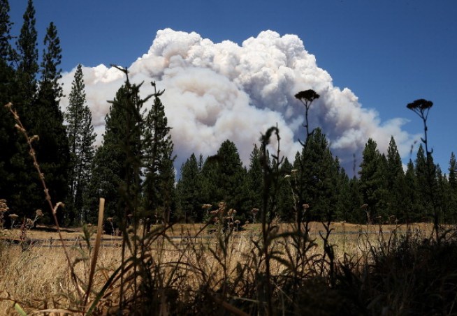 DC-10: 
|
|
|
Re: Rim Fire near Yosemite
|
Joined: Sep 2009
Posts: 8,529 Likes: 107
|
|
OP
Joined: Sep 2009
Posts: 8,529 Likes: 107 |
"MAFFS 6" is a "Modular Airborne FireFighting System" loaded onto a C-130 cargo plane. 
|
|
|
Re: Rim Fire near Yosemite
|
Joined: Sep 2009
Posts: 1,261
|
|
Joined: Sep 2009
Posts: 1,261 |
Several threads covering the Rim fire on the Yosemitenews.info forum
The body betrays and the weather conspires, hopefully, not on the same day. 
|
|
|
Re: Rim Fire near Yosemite
|
Joined: Jun 2010
Posts: 319
|
|
Joined: Jun 2010
Posts: 319 |
Bee, thanks for the link. This is one horrendous fire.
Is the smoke on the WZ camera from this fire?
|
|
|
Re: Rim Fire near Yosemite
|
Joined: Jul 2011
Posts: 13
|
|
Joined: Jul 2011
Posts: 13 |
Steve, wow intense picture of Groveland. I am glad your sis headed for safety. I hope things get contained..I have same question as was just posed by Wazzu. Is the smoke from Yosemite impacting Whitney web cam? You can see the smoke on Mt Williamson webcam as well. I had thought the wind was blowing northward.
|
|
|
Re: Rim Fire near Yosemite
|
Joined: Sep 2010
Posts: 46
|
|
Joined: Sep 2010
Posts: 46 |
The following link will always display the most perimeter of the Rim Fire straight from the GeoMAC server. This is the same server that also provides data to the crews on the fire line. Sometimes the data on the InciWeb site is not as current as the data that comes from the GeoMAC server. (The InciWeb site gets its data from GeoMAC.) For more information about this map, you can follow the “About” link in the upper left corner of the map. http://www.mappingsupport.com/p/fires/2013_rim_fire_map.htmlJoseph, the Gmap4 guy
|
|
|
Re: Rim Fire near Yosemite
|
Joined: Sep 2009
Posts: 1,261
|
|
Joined: Sep 2009
Posts: 1,261 |
I can see the Rim fire smoke line from the foothills, and the smoke line does not spread south beyond the localized fire area (can't say the same for the north, though, because the smoke line travels for miles)
The body betrays and the weather conspires, hopefully, not on the same day.
|
|
|
Re: Rim Fire near Yosemite
|
Joined: Apr 2012
Posts: 579 Likes: 3
|
|
Joined: Apr 2012
Posts: 579 Likes: 3 |
Is the smoke on the WZ camera from this fire?
I doubt the smoke is from the rim fire. I drove over sr 108 today, and the smoke was very thick in that area. By the time I got down to hwy 120/395 the air was clear.
|
|
|
Re: Rim Fire near Yosemite
|
Joined: Sep 2009
Posts: 8,529 Likes: 107
|
|
OP
Joined: Sep 2009
Posts: 8,529 Likes: 107 |
Joseph's Gmap4 site is pretty doggone amazing. I sure like using the site, Joseph!
Blue Grouse, I think you were correct about the smoke being from the Fish Fire. Since the Mt Williamson webcam showed more clear skies, the Whitney smoke had to be coming from the southwest.
In fact, playing with Joseph's Gmap4 fire link, I can zoom out, and there are arrows showing the prevailing wind direction, and it shows the Fish Fire directly upwind of Owens Lake. The Rim Fire smoke is blowing northeast over to Nevada.
|
|
|
Re: Rim Fire near Yosemite
|
Joined: Aug 2010
Posts: 632
|
|
Joined: Aug 2010
Posts: 632 |
I hope mother nature will bring showers to the fire to help the fire fighters. I think about all the animals of the forest trying to survive. I also think of all the plant life going up in smoke.
Lynnaroo
|
|
|
Re: Rim Fire near Yosemite
|
Joined: Sep 2010
Posts: 46
|
|
Joined: Sep 2010
Posts: 46 |
I added the current hot spot data to the online map link that I posted earlier. This likely shows the areas where the fire is trying to expand. See the "About" link in the upper left corner of the map for more information. http://www.mappingsupport.com/p/fires/2013_rim_fire_map.htmlJoseph, the Gmap4 guy
|
|
|
Re: Rim Fire near Yosemite
|
Joined: Oct 2009
Posts: 2,251 Likes: 1
|
|
Joined: Oct 2009
Posts: 2,251 Likes: 1 |
Here are pictures from a Perth newspaper. PS. A fortnight is two weeks...
Verum audaces non gerunt indusia alba. - Ipsi dixit MCMLXXII
|
|
|
Re: Rim Fire near Yosemite
|
Joined: Sep 2009
Posts: 8,529 Likes: 107
|
|
OP
Joined: Sep 2009
Posts: 8,529 Likes: 107 |
Yosemite National Park has announced today that they will be closing Tioga Road due to the Rim Fire. I heard today that the fire is the largest ever recorded in the Sierra. From the Yosemite NPS website: Tioga Road (Hwy 120 through the park) will close from Crane Flat to Yosemite Creek on Aug 28 at noon
Beginning at noon on Wednesday, August 28, the Tioga Road (Highway 120 through the park) will be closed from Crane Flat to Yosemite Creek. The only access to the Tuolumne Meadows area will be via Highway 120 from near Lee Vining.
Big Oak Flat Road (Hwy 120 entrance from the west is closed); most of Yosemite is open
The Big Oak Flat Road (Highway 120 from the west) from the Big Oak Flat entrance to Crane Flat is closed due to the Rim Fire. Entrances to Yosemite via Highways 41 and 140 are open. While most of the park is open, some areas are temporarily closed.
|
|
|
Re: Rim Fire near Yosemite
|
Joined: Sep 2009
Posts: 583
|
|
Joined: Sep 2009
Posts: 583 |
PS. A fortnight is two weeks... And a furlong/fortnight is 0.000372 mph.
|
|
|
Re: Rim Fire near Yosemite
|
Joined: Oct 2009
Posts: 2,251 Likes: 1
|
|
Joined: Oct 2009
Posts: 2,251 Likes: 1 |
Verum audaces non gerunt indusia alba. - Ipsi dixit MCMLXXII
|
|
|
Re: Rim Fire near Yosemite
|
Joined: Sep 2009
Posts: 8,529 Likes: 107
|
|
OP
Joined: Sep 2009
Posts: 8,529 Likes: 107 |
Here's a picture from Sonora posted on Facebook today:  I read today that the fire has now burned 200,000 acres. That is 315 square miles. It is reported 32% contained. What a monster. I vote for this from now on: Every fall, before the first big storm is due to hit, fly crop-dusters over the forest and drop fire-starting "bombs" all over the place. Then the storm could move in and put them out. Small fires would clear the forests of the century of fuel, preventing future catastrophes like this.
|
|
|
Re: Rim Fire near Yosemite
|
Joined: Sep 2009
Posts: 8,529 Likes: 107
|
|
OP
Joined: Sep 2009
Posts: 8,529 Likes: 107 |
Here's a Yosemite N.P. time lapse video Rim Fire Time Lapse, August 2013Time-lapse photography shows various perspectives of the 2013 Rim Fire, as viewed from Yosemite National Park. The first part of this video is from the Crane Flat Helibase. The fire is currently burning in wilderness and is not immediately threatening visitors or employees. The second half of the video is from Glacier Point, showing Yosemite Valley, and how little the smoke from the fire has impacted the Valley.
|
|
|
Re: Rim Fire near Yosemite
|
Joined: Oct 2009
Posts: 2,251 Likes: 1
|
|
Joined: Oct 2009
Posts: 2,251 Likes: 1 |
A Predator UAV is gathering data on the fire. Report here.
Verum audaces non gerunt indusia alba. - Ipsi dixit MCMLXXII
|
|
|
Re: Rim Fire near Yosemite
|
Joined: Jan 2010
Posts: 1,034
|
|
Joined: Jan 2010
Posts: 1,034 |
Here's a Yosemite N.P. time lapse video Rim Fire Time Lapse, August 2013Time-lapse photography shows various perspectives of the 2013 Rim Fire, as viewed from Yosemite National Park. The first part of this video is from the Crane Flat Helibase. The fire is currently burning in wilderness and is not immediately threatening visitors or employees. The second half of the video is from Glacier Point, showing Yosemite Valley, and how little the smoke from the fire has impacted the Valley. sad when government agencies start using facebook and other services that force users to sign up and give up personal information to be able to access resources such as this video. This video does not play unless you have a facebook account, or something is broken here today. All in the name of saving money, but hell will freeze over before I sign up with Zuckerberg's voluntary personal information donation service.
|
|
|
|
|